“Take the Folsom-Dolores Diagonal To 826 South Market”

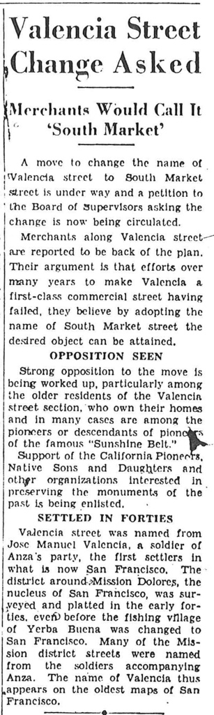
Eric Fischer brings us news that the merchants of Valencia Street are considering renaming Valencia to “South Market”.

(Wait, what’s that, Eric? I thought you said it was in the Chronicle? Ohhhh, in 1935, got it.)

“Efforts over many years to make Valencia a first-class commercial street having failed, they believe by adopting the name of South Market the desired object can be attained.”

Needless to say, the California Pioneers were unamused.

I am sure the merchants of 1935 would look upon the oasis that is Valencia St with abject horror. Then again, the shots we have of pre-1930 Valencia St certainly seem that they could have been trying harder.

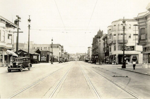
1929 , looking  south down Valencia towards 24th. image via SFPL

Lest we be too hard on our great-grandparents, do note their first effort at parklets above — check out the sandbags on the right of the tracks in this shot. (Bonus points to whomever correctly guesses what they are.)

Another item captured by Eric Fischer (half-man, half-scanner) is “the Folsom-Dolores Diagonal”, a 1928 plan to convert the Southern Pacific Railway right of way into a boulevard. Eric’s original scan is on his Flickr page, but I have taken the liberty of highlighting and de-diagonalizing it for our viewing pleasure.

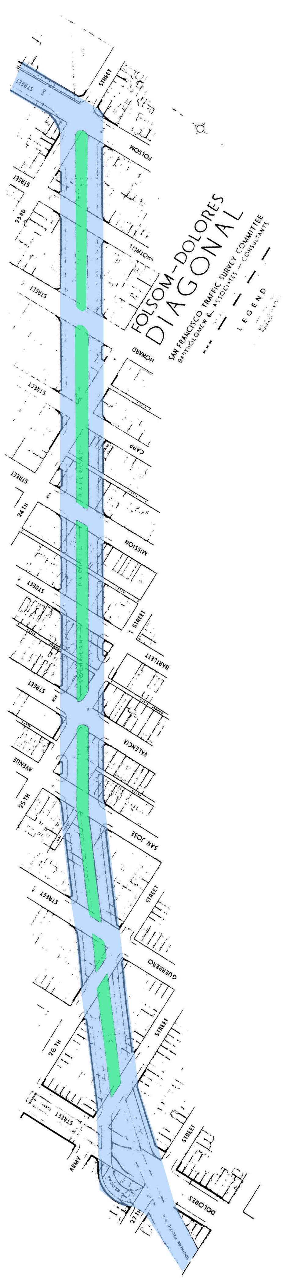
The Folsom-Dolores Diagonal is certainly no Mission Freeway — oh, 1928 city planners, why did not not dare to dream!

Remember this was just as they were widening the Bernal Cut (today’s San Jose exit from 280) so they were considering increased traffic flow into the city.  Remember also there was no 101 / Bayshore Freeway yet —  just the Bayshore *Highway*, aka today’s Bayshore Boulevard, which was also under construction in 1928.

I’ve highlighted in yellow one mysterious notation on our diagonal map:

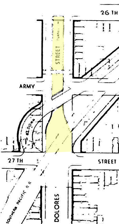
Correct me if I’m wrong, but does that say “Dolores Street Tunnel?There’s some pretty serious grade between 27th and 26th on Dolores (there actually was a Dolores street bridge for the old railroad) so topolographically it makes sense. But to a tunnel where? The secret bathrooms at Dolores Park? I vaguely remember 1920s transit plans for subway emerging at 26th and Dolores but I will be damned if I can find it now.

UPDATE: Eric found it – it was in the 1937 SF transit plan where a subway would run underneath the SPRR RoW.

Other detail on Eric’s map includes our utterly whacked Mission / Dolores / San Jose / Randall intersection (the very tip of La Lengua) – it seems to have been implemented then:

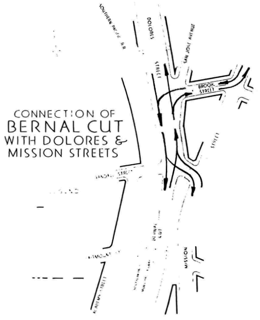
If you need that many arrows, you have failed, sirs. Also, San Jose Ave was entertainingly narrow.

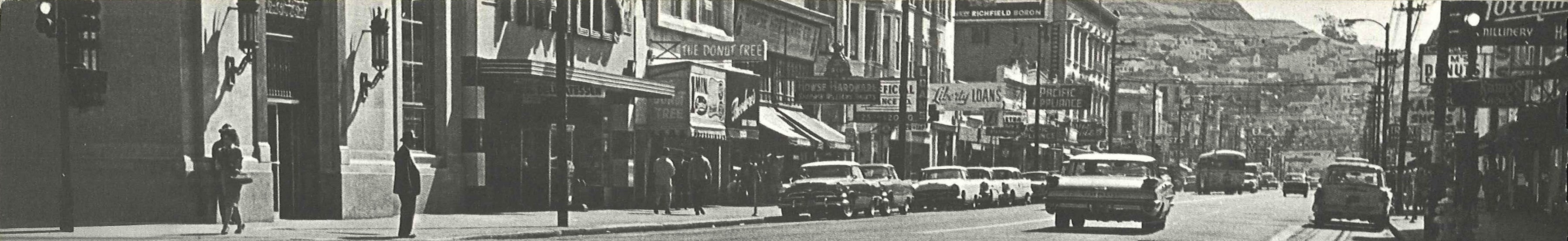
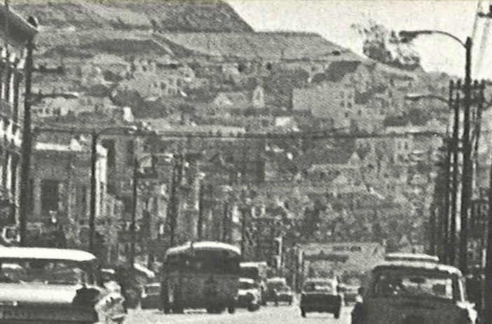
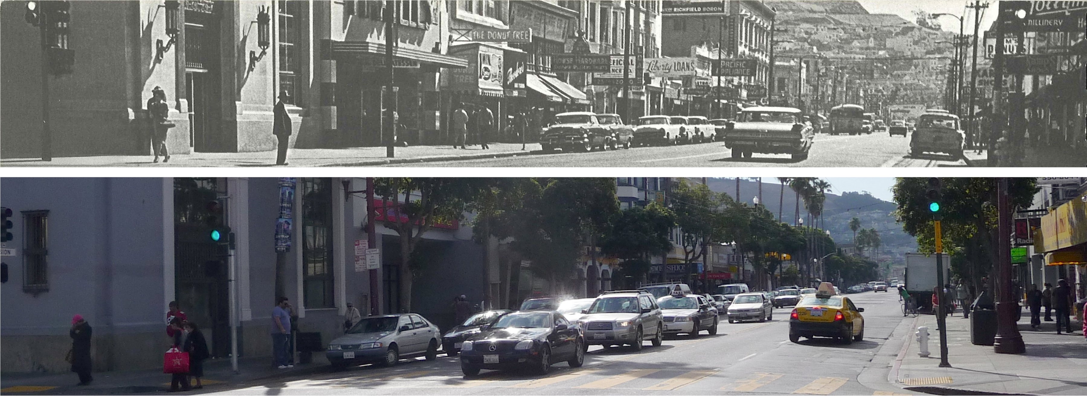
Take a look at this 1927 SFPL shot looking south down San Jose Ave, across 30th.  It is completely unrecognizable compared to today. It seriously took me an hour to figure out it – even with my before/after shot it still makes my head hurt.

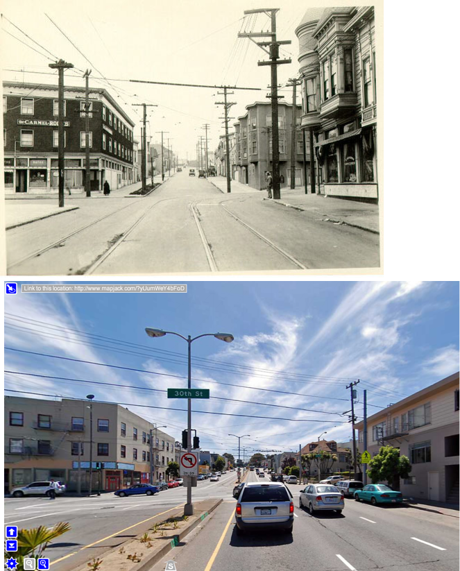
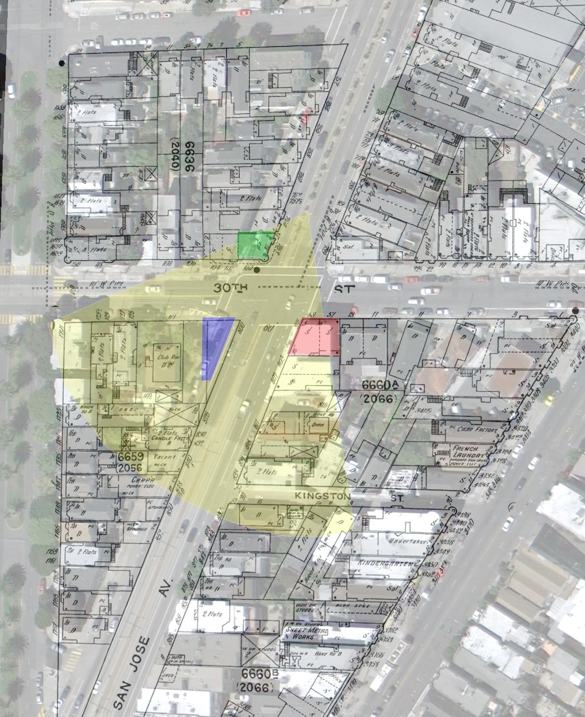
The buildings on the right (west) were all torn down when they widened San Jose and Guerrero in the 1950s. Google Earth Overlay below (click to zoom). Yellow estimates field of view for the 1927 photo.

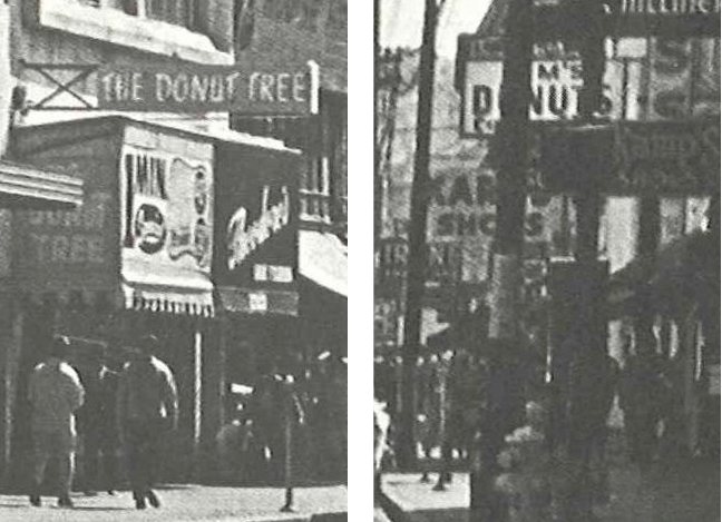
The green overlay was the saloon you see on the right hand side of the old picture (note the fancy rounded turret window thing). Blue were the apartments across 30th on the right. All those are long gone.

The red overlay is the Carmel (a boarding house if I’m not mistaken). I really don’t know if it’s the same structure — it’s a strange shaped lot, so you kind of have to make a building in that shape. Windows seem to be in different locations too, so I’m skeptical.

Such is the actual and retrofuture Mission and La Lengua in the 1920s and 30s.

’62 Mission, Proto-Farolito

The esteemed Eric Fischer brings us scans of BART plans from 1962. This shot looks south down (and under) 
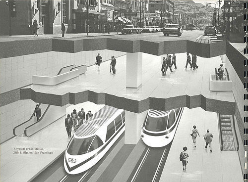
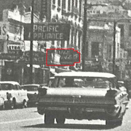
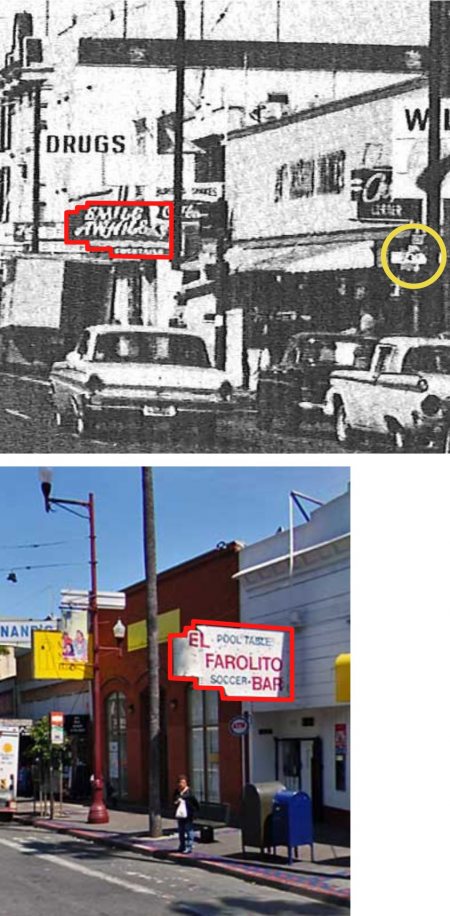
Mission from 23rd towards 24th:

The Look of Rapid Transit: 24th Street Mission station

The interesting part (outside of the fact that the BART station was to be so brilliantly lit that men wearing hats would cast stark shadows) is the street photo up top — it was taken from the NW corner of 23rd and Mission, looking south towards Bernal. (Click the image for a big-ass high resolution version.)

Particularly striking is the utter lack of trees (even on the slopes of Bernal).

Lots of donuts though:

Matching shot from today.  The trees make it hard to compare, but changes a plenty. (Click to enlargify.)

Zooming in towards 24th (above the epic car) we see the epic “Smile Awhile” bar:

A more clear view is available from the south.  It should quickly become clear what that sign represents today:

Much more on the history of 24th and Mission, both imagined and realized, over at Burrito Justice from a few months back.

Inverse Square Law Lost Upon Board of Sups

Bernalwood has done a fine job highlighting the NIMBY, faux-science opposition to new cell and data towers in San Francisco, and the rather pathetic response by our Board of Sups, using graffiti as NIMBY cover:

All it takes to kill an effort to provide Bernal Heights and our surrounding neighborhoods with some 21st century wireless technology is a group of addled NIMBYs and a thin veneer of recently applied graffiti. But improving service requires a master plan. Which may get written. After some research. Someday. Perhaps.

And there’s a hearing today on cell phone towers and “the City’s beauty”:

The next battle will take place in the lame-duck chambers of the San Francisco Board of Supervisors, where progressive Supervisor John Avalos will hold public hearings today on a piece of legislation he introduced (with backing from Bernal Heights Supervisor David Campos) to “regulate the placement of [mobile antennas] in order to prevent telecommunications providers from installing wireless antennas and associated equipment in the City’s rights-of-way either in manners or in locations that will diminish the City’s beauty.”

Even if you don’t read the rest of my diatribe, at least go to Bernalwood to see what you can do.

Unsurprisingly, stupid spreads. Note this recent entertainingly hysterical petition against a proposed cell tower on 24th & Harrison:

To:  San Francisco Planning Commission
24th Street Neighborhood Against Cell Tower on 24th & Harrison

T-Mobile is trying to install an Industrial 6-Panel Facility (Antenna Tower) that is unnecessary, undesirable and not compatible with our predominantly residential neighborhood.

This type of antenna tower contains hazardous materials and equipment. This equipment is going to be installed on a residential building in this densely populated neighborhood.

The backup batteries are made with hydrogen gas, a very explosive substance, and under certain conditions can ignite and explode.

Lower 24th Street Association has done field studies in the surrounding area and has found the coverage is already “good” to “excellent” in our neighborhood, therefore this facility is unnecessary.

The Planning Commission Hearing is scheduled for Thursday, January 13, 2011 beginning at 1:30pm or later in City Hall, 1 Carlton B. Goodlett Place, Room 400

For more information please email Beth at noantennasSF@gmail.com

ZOMG EXPLOSIVE GAS.  And SIX panels!  The end is nigh. (I suggest that you go to this petition and indicate your support for the tower.)

Uptown Almanac recently smacked their collective foreheads upon T-mobile’s spinelessness upon encountering fake-science NIMBYsistance:

Remember back when we laughed at a completely ludicrous protest of NIMBY neighbors claiming that making cellphones work in the northwest corner of the Mission would hurt the children?  Well, guess what, the protest actually fucking worked.  In spite of the fact there is no scientific proof backing their claims that the celltower would cause you to turn into a swamp monster, T-Mobile backed down and withdrew their permit application.

As for AT&T, their poor reception in the Mission is legendary.  A modern day Data Bermuda Triangle, it’s the Sargasso Sea for 3G. I created this animated map from an app that measures signal strength on the iPhone.

Note how the towers are few and far between compared to the rich electromagnetic fields of La Lengua.  (I tried this around Dolores Park and down 18th but it was pointless as I could barely get any meaningful signal.)

Here’s the deal, NIMBYs.  I know you didn’t pay any attention in high school, but it’s been well known since the 17th century that electromagnetic radiation (which has nothing to do with scary Three Mile Island radiation, you nitwits) dissipates according to the inverse square law.

  • Unless you are standing right next to the tower, the “radiation” pales in comparison to the energy transmitted by your cell phone.
  • The fewer cell phone towers there are, the harder your cell phone has to work to talk to them.  Which means your phone starts beaming EVEN MORE ENERGY INTO YOUR SKULL.
  • More cell phone towers means your phone uses LESS energy to transmit (and your battery lasts longer too, which does me little good as I then am more likely to have to listen to whatever hypocritical conversation you happen to be having on your radiation transmission device).

And Board of Sups, be forewarned: San Francisco has 7081 bachelor and college degrees per square mile, the highest in the country. Even in your district, Mr. Campos: the 94110 holds over 18,000 residents (34%) with at least a 4 year degree that are capable of the most rudimentary critical analysis of your record and not voting for you again. (Not that you need a degree to figure this out.)

(image via Bernalwood)

As Senator Daniel Moynahan once said, “Everyone is entitled to his own opinion, but not his own facts.”

Corollary:  Science: it works, bitches. (XKCD)

As for what you can do, follow the lead of Bernalwood:

Supervisor Avalos will hold a hearing on his proposal today at 1 pm in front of the City’s Land Use Committee. If you can’t attend the meeting (because you have, you know, a job and a life) public comment can be submitted via Alisa Somera in the Clerk’s office at 415.554.4447 or Alisa.Somera@sfgov.org. (NOTE: Be kind to Alisa, please. The legislation isn’t her idea, nor her fault.)

Diatribe off. Back now to your regularly scheduled hipster news.

Why Isn't There An Apple Store in the Mission?

Why no Apple love in the Mission? You’d think this is something even Chicken John could get behind.

The only question is where? On Mission? Or Valencia? A few proposals:

The Social Security Building / old Hibernia Bank on Valencia and 22nd and Valencia:

Pros: Apple-eqsue architecture
Cons: even longer Boogaloo lines

Dolores Park Castle:

Pros: empty building finally used; good WiFi coverage for the park; nice park to rest in while awaiting Genius Bar appointments
Cons: dark wood beams may conflict with Steve Jobs beech aethsetic; Pottery Barn may attempt to move into Christian Science Church next door

Dolores Park Bathrooms:

Pros: Even better WiFi coverage in DP; safe refuge for Blue Bottle; clean bathrooms
Cons: white Apple logo easily tagged

Please add your suggestions in the comments.

(top photo by Chris Carlsson; Apple logo via Wikipedia)

The Roof is on Fire (Truck)

Here’s a 270º panorama I made of the fire truck climbing and dancing crowd.

(1500 pixel version for those reading in RSS. Click for the full 10,000 pixel version over at Burrito Justice. Sorry if it breaks your Internet.)

And the white-shirt wearing, fist-shaking, last man standing, with blue lights below:

Jesse from Beer & Nosh has more shots of our fire truck roof dancing friends.

Armand On The Mission

Recent J-school graduate, Mission Local alumni, and black & white photographer extraordinaire Armand Emamdjomeh is at the De Young!

…the short video I made as part of my thesis project, New Mission, is going to be showing as part of the Friday Film Night at the De Young Cultural Encounters series! It’s basically a slideshow of my Mission photography, with little bits of video, all to the narration of the poem “In Twenty Years” by Marcella Ortiz.

It’s kind of an ode to the neighborhood and the character that it has now.

It will be part of this very Friday Film Night at the De Young Cultural Encounters. The event is free!  (Facebook event page here if that’s how you roll.)

If you can’t make it, Armand’s work will also be at SF City Hall on the 16th at the Night/Light exhibit.

(Someone get this man a job so he can stay in the Mission, OK?)

Sunday Streets, Mission Edition, June 20

Just posted: the route map for the (first of two) Mission Sunday Streets on June 20th. Biggest difference — this year, Harrison gets carless, and it runs to 3pm instead of 2pm.

Not yet on their web site, but some details on Facebook.

As a reminder, here’s 24th St last year:

Don’t forget to move your cars this time around, OK?

Carne Asada Fries, Mission Cries

Brainslip paints a sobering alternate history of a Mission under the influence of LA foodstuffs. Carne asada fries are a slippery slope, my friends:

First it started with the dreaded droopy carne asada fry invasion.

Then they took pizza. How could we lose pizza? Well, we did, to a cardboard tasting menace called Dominos, which began to infiltrate the Mission block by block from 30th to Division, Guerrero to Potrero. Heroes fell one after the other – Papa Potrero, Serrano, Cybelle, and perhaps remembered most fondly- Zante.

You can take my Indian pizza from my cold, dead hand.

Next up: tacos – soon deep fried was all they tried – Baja style. No more boiled chicken, shredded pork, sauteed fish, etc.

Scared?  You should be.  It gets worse:

After a year of sensory dullification we lost the only thing that mattered: burgers. In-N-Out opened at 20th @ Valencia. A bikes only drive-thru , how could we resist? Free air, free water, valet bike parking: all so delightful.

First they came for the pizza. And I didn’t speak up because there was too much bufala.

Then they came for the taquerias.  And I didn’t speak up because there was too much pollo asado.

Such SoCalized medicine flooded the streets. Everywhere were carts, huts, & shacks – all shaped in the like of their foodstuffs. A nonstop barrage of fried chicken, chili fries, and pastrami became too much for neighborhood morale. Defeated, they gave up what mattered most, and signed over the rights to their BART tube for conversion to a freeway tunnel.

Oh dear.  Food has consequences. The Great War of the Californias indeed.

Tetris Treat

In a noble (yet likely futile) effort to break the recent worrisome trend of pigeon-biased posts, I bring you street art, Tetris style:

(Taken on Treat & 23rd by rhiannononon.)

The only possible improvement to this would be to color each sidewalk square as a tetris block, visible from Google Maps.

Then again, Mexist took it a step beyond, mapping out 8-bit 1978 onto streets laid out a century earlier.

Viva 8-bit Mission!

Major League Mission

Telstar Logistics. Laughing Squid. Burrito Justice. Mission Mission. What happens when they join forces? Mission Blog Force 2010! A veritable historical mapgasm ensues.

Laughing Squid and Telstar Logistics recently exposed us to the historical imagery feature in Google Earth.  San Francisco’s 1946 layer proved irresistible, especially concerning the old SF Seals baseball stadium, now home to the Potrero Safeway and Office Depot.

As is inevitable amongst map wonks, the Telstar Logistics and Burrito Justice mapping teams started to wonder exactly where in the stores the bases were located. The alignment of the 1947 photomap is a little wobbly in Google Earth (it’s off by 30-100 feet) so we turned to another favored source for greater precision, Sanborn maps overlaid in GE. Behold the diamond of history.

In the world’s first blogging simulcast, you can see the raw base photos of the Telstar Logistics Surveying Unit along with painfully detailed overlay maps by the Burrito Justice Research Department. Telstar Logistics historical analysis will be available on Laughing Squid posthaste.

For some perspective (because that’s how we roll) here’s opening day for the Giants in 1959, their first game against LA. That’s 16th on the top and Bryant on the right.

Note that history was made recording history: a blogger ACTUALLY LEFT HIS HOME and went on-site to determine that home plate and 1st are located in Office Depot, while 2nd and 3rd base in Safeway.

Below, blue tape marks third base, looking towards home plate.  (Torillas in front of you, and frozen pizzas behind you, as is so often the case when you’re trying to steal home.)

To make this post even more relevant to the Mission — Seals Stadium was also home to the Mission Reds (aka the Missions) before they moved down to Hollywood in 1938.

And prior to Seal Stadium’s construction in 1930, both teams played at 14th and Valencia at Recreation Park. Think of that next time you’re at Four Barrel.

More photos and maps at TL, LS, and BJ.